Oxia Palus quadrangle
The Oxia Palus quadrangle is one of a series of 30 quadrangle maps of Mars used by the United States Geological Survey (USGS) Astrogeology Research Program . The Oxia Palus quadrangle is also referred to as MC-11 (Mars Chart-11). [1]
Page Revisions
| Year | Metadata | Sections | Top Words | First Paragraph |
| 2018 |
262121 characters 25 sections 157 paragraphs 133 images 362 internal links 59 external links |
3. Other results from Pathfinder |
hiwish 0.372 hirise 0.369 layers 0.319 crommelin 0.279 program 0.199 oxia 0.175 crater 0.167 view 0.150 danielson 0.135 aram 0.133 firsoff 0.130 pedestal 0.128 chaos 0.117 palus 0.117 springs 0.102 |
The Oxia Palus quadrangle is one of a series of 30 quadrangle maps of Mars used by the United States Geological Survey (USGS) Astrogeology Research Program . The Oxia Palus quadrangle is also referred to as MC-11 (Mars Chart-11). [1] |
| 2017 |
243777 characters 25 sections 137 paragraphs 116 images 360 internal links 53 external links |
3. Other results from Pathfinder |
hirise 0.352 hiwish 0.316 layers 0.302 crommelin 0.210 oxia 0.193 crater 0.176 program 0.171 danielson 0.157 aram 0.155 firsoff 0.151 pedestal 0.148 palus 0.136 chaos 0.127 springs 0.119 view 0.106 |
The Oxia Palus quadrangle is one of a series of 30 quadrangle maps of Mars used by the United States Geological Survey (USGS) Astrogeology Research Program . The Oxia Palus quadrangle is also referred to as MC-11 (Mars Chart-11). [1] |
| 2016 |
199699 characters 24 sections 108 paragraphs 89 images 347 internal links 30 external links |
3. Other results from Pathfinder |
hirise 0.296 layers 0.267 crommelin 0.237 oxia 0.236 danielson 0.192 hiwish 0.189 firsoff 0.184 crater 0.183 palus 0.166 springs 0.145 aram 0.137 chaos 0.122 rocks 0.117 program 0.104 becquerel 0.096 |
The Oxia Palus quadrangle is one of a series of 30 quadrangle maps of Mars used by the United States Geological Survey (USGS) Astrogeology Research Program . The Oxia Palus quadrangle is also referred to as MC-11 (Mars Chart-11). [1] |
| 2015 |
173761 characters 18 sections 93 paragraphs 77 images 311 internal links 30 external links |
3. Other results from Pathfinder |
hirise 0.287 crommelin 0.264 layers 0.238 oxia 0.236 firsoff 0.205 crater 0.178 palus 0.164 springs 0.161 hiwish 0.155 aram 0.153 chaos 0.135 rocks 0.130 becquerel 0.107 vallis 0.098 water 0.097 |
The Oxia Palus quadrangle is one of a series of 30 quadrangle maps of Mars used by the United States Geological Survey (USGS) Astrogeology Research Program . The Oxia Palus quadrangle is also referred to as MC-11 (Mars Chart-11). [1] |
| 2014 |
150306 characters 17 sections 74 paragraphs 59 images 301 internal links 24 external links |
3. Other results from Pathfinder |
hirise 0.273 oxia 0.236 layers 0.206 springs 0.194 palus 0.184 aram 0.183 chaos 0.162 rocks 0.156 becquerel 0.128 crater 0.128 hiwish 0.121 vallis 0.117 water 0.117 mojave 0.117 ares 0.106 |
The Oxia Palus quadrangle is one of a series of 30 quadrangle maps of Mars used by the United States Geological Survey (USGS) Astrogeology Research Program . The Oxia Palus quadrangle is also referred to as MC-11 (Mars Chart-11). [1] |
| 2013 |
148299 characters 17 sections 73 paragraphs 58 images 295 internal links 25 external links |
3. Other results from Pathfinder |
hirise 0.271 oxia 0.235 layers 0.205 springs 0.193 palus 0.183 aram 0.182 chaos 0.161 rocks 0.155 mojave 0.139 crater 0.131 becquerel 0.127 hiwish 0.120 vallis 0.116 water 0.116 ares 0.106 |
The Oxia Palus quadrangle is one of a series of 30 quadrangle maps of Mars used by the United States Geological Survey (USGS) Astrogeology Research Program . The Oxia Palus quadrangle is also referred to as MC-11 (Mars Chart-11). [1] |
| 2012 |
146607 characters 17 sections 73 paragraphs 57 images 294 internal links 25 external links |
3. Other results from Pathfinder |
hirise 0.279 oxia 0.219 layers 0.205 springs 0.193 aram 0.182 palus 0.171 chaos 0.162 rocks 0.156 mojave 0.139 hiwish 0.131 crater 0.131 becquerel 0.127 vallis 0.116 water 0.116 ares 0.106 |
The Oxia Palus quadrangle is one of a series of 30 quadrangle maps of Mars used by the United States Geological Survey (USGS) Astrogeology Research Program . The Oxia Palus quadrangle is also referred to as MC-11 (Mars Chart-11). [1] |
| 2011 |
87331 characters 17 sections 61 paragraphs 41 images 152 internal links 19 external links |
3. Other Results from Pathfinder |
hirise 0.222 oxia 0.208 aram 0.202 springs 0.194 layers 0.184 chaos 0.163 palus 0.162 mojave 0.154 rocks 0.154 crater 0.145 becquerel 0.141 vallis 0.129 water 0.120 ares 0.117 formed 0.117 |
The Oxia Palus quadrangle is one of a series of 30 quadrangle maps of Mars used by the United States Geological Survey (USGS) Astrogeology Research Program . The Oxia Palus quadrangle is also referred to as MC-11 (Mars Chart-11). [1] |
| 2010 |
82249 characters 17 sections 57 paragraphs 37 images 147 internal links 18 external links |
3. Other Results from Pathfinder |
hirise 0.212 aram 0.208 springs 0.200 oxia 0.196 layers 0.180 chaos 0.167 mojave 0.159 palus 0.153 rocks 0.149 becquerel 0.145 crater 0.133 vallis 0.133 water 0.123 ares 0.121 formed 0.114 |
The Oxia Palus quadrangle is one of a series of 30 quadrangle maps of Mars used by the United States Geological Survey (USGS) Astrogeology Research Program . The Oxia Palus quadrangle is also referred to as MC-11 (Mars Chart-11). [1] |
| 2009 |
69707 characters 12 sections 50 paragraphs 36 images 131 internal links 12 external links |
1. What does the surface look like 3. Other Results from Pathfinder |
aram 0.236 hirise 0.231 springs 0.227 layers 0.194 chaos 0.190 becquerel 0.165 rocks 0.148 oxia 0.142 bar 0.128 water 0.124 crater 0.123 pathfinder 0.119 ares 0.117 formed 0.116 vallis 0.113 |
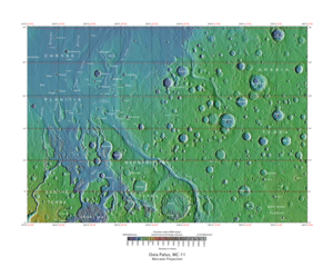
The Oxia Palus quadrangle covers the region of 0° to 45° west longitude and 0° to 30° north latitude on Mars . Mars Pathfinder landed in the Oxia Palus quadrangle at 19.13° N and 33.22° W, on July 4, 1997. Crater names in Oxia Palus are a Who's Who for famous scientists. Besides Galilaei and DaVinci , some of the people who discovered the atom and radiation are there: Curie , Becquerel , and Rutherford . [1] NASA's next Mars rover, the Mars Science Laboratory , may be sent to Mawrth Vallis . A variety of clay minerals have been found there. Clay is formed in water, and it is good for preserving microscopic evidence of ancient life. [2] Recently, scientists have found strong evidence for a lake that received drainage from Shalbatana Vallis. The study carried out with HiRISE images indicates that water formed a 30-mile-long canyon that opened up into a valley, deposited sediment, and created a delta. This delta and others around the basin imply the existence of a large, long-lived lake. Of special interest is evidence that the lake formed after the warm, wet period was thought to have ended. So, lakes may have been around much longer than previously thought. [3] [4] |